

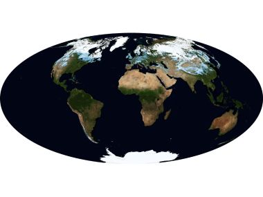
This is a layered colored global topographic map generated from satellite remote sensing data. With pure black background, it fully shows the outlines of seven continents and Antarctica. Different colors correspond to different land elevations, intuitively distinguishing plains, mountains, plateaus and basins. It is a common visualization material for geography popularization and geoscience research with space overlooking perspective.
Satellite Remote Sensing Global Colored World Topographic Map
1
0
0
0
📁 Also featured in1

🔗 Repost
✍️ Author猫猫壁纸酷
🔗 Source URLwww.wallcoo.com


Comments 0