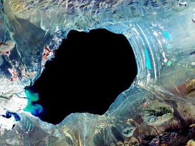
This is a satellite aerial image of Antarctic Dry Valleys captured by NASA. As the most special ice-free area on the Antarctic continent, most of its surface is exposed dark rocky mountains, with scattered snow on high altitudes, light blue glacial melt lakes dotted in valleys, surrounded by flowing glaciers. It is the extreme desert on Earth most similar to Mars, with desolate magnificent landscape and high polar scientific research value.

Nasa Satellite Aerial View Antarctic Dry Valleys Glacier Landscape

1600×1200 @ 445.3 KB | Category:Landscape

1 0 0 0
Download
📷 More from this author
Artistic Satellite Aerial View Of Lena River Delta LandscapeNasa Mars North Pole Frost Sand Dunes Aerial PhotoSatellite Aerial View Of Giant Dust Cyclone Sandstorm On EarthSatellite Aerial Photo Of Plateau Salt Lake In Tibet ChinaMacro Photography Of Curled Fern LeafEaster Eggs Nest On GrassHuge Ancient Tree At Seaside Coastal Natural Scenery WallpaperCat In Heart Shaped Hole On Blue DoorAutumn Lone Yellow Tree In Field Blue Sky WallpaperLoworks Surreal Graffiti Sea Cartoon Island IllustrationAutumn Clear Sky Red Maple Leaves Low Angle Shot WallpaperSunny Summer Young Girl Relaxing On Outdoor Terrace With Drinks

Comments 0

Loading comments…