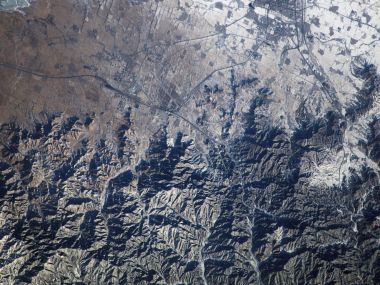
This is a remote sensing satellite aerial view of an inland salt lake on the Tibetan Plateau, China. The nearly pitch-black main lake area occupies the center of the frame, with salt marshes, gullies and desert landforms of rich color layers distributed around the shore. The original geological features of the high-altitude no-man's land show the unique abstract artistic beauty of the Earth.

Satellite Aerial Photo Of Plateau Salt Lake In Tibet China

1600×1200 @ 558.4 KB | Category:Landscape

3 0 0 0
Download
📷 More from this author
Antarctic Ice Shelf Break Satellite Aerial Polar Iceberg LandscapeSatellite Image Of New York World Trade Center After 911 IncidentSatellite Aerial Photo Of Bahamas Tropical Ocean LandscapeSpace Aerial View Of North China Yanshan Winter LandscapeKorean Instyle Magazine Celebrity Dark Fashion PortraitSuperman Man Of Steel WallpaperBacklit Translucent Red Autumn Leaf CloseupGreat Smoky Mountains National Park LandscapeTremola Road Switzerland Night ViewLomo Style Abandoned Room La Touche Old StoveJapanese Shimogamo Shrine Stone Railing With Red Maple LeavesAutumn Backlit Red Maple Leaf Close Up

Comments 0

Loading comments…