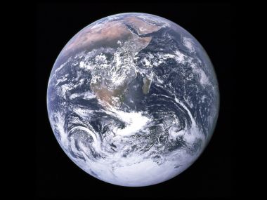
This is a public satellite composite full-view image of Earth released by NASA, using elliptical projection to present global sea-land distribution. It clearly shows large-scale snow cover in the Northern Hemisphere in winter, with all continental plates and complete polar ice caps presented. It is a highly valuable popular science geographic image with grand visual effect.

Nasa Satellite Earth Full View Northern Hemisphere Snow Map

1600×1200 @ 154.0 KB | Category:Landscape

1 0 0 0
Download
📷 More from this author
Classic Blue Marble Full Earth View From SpaceSatellite Aerial View Of Giant Dust Cyclone Sandstorm On EarthSatellite Remote Sensing Global Colored World Topographic MapSatellite Overview Of Desert Dendritic Water System LandscapeCartoon Snowman Snow Castle Fox IllustrationOlympus Retro Camera Butterfly DesignGreat Smoky Mountains National Park LandscapeOkinawa Beach And Green Island SceneryDiepenbeek Belgium Countryside Sunset Glow LandscapeJapan Plateau Winding Road Summer Natural LandscapePraia Da Dona Ana Beach Algarve PortugalBlue Green Fantasy Demoness Alien Cave Game Art Dual Screen Wallpaper

Comments 0

Loading comments…