

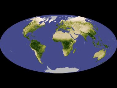
This is a high-precision Earth satellite visualization rendering against pure black cosmic background. It clearly presents the full view of the Western Hemisphere, showing complete outlines of North America, Central America and South America with marked national borders. Different blue-green ocean tones indicate water depth, while different land colors mark vegetation coverage and terrain elevation. It is a high-definition geographic image with great popular science value.
Earth Western Hemisphere North South America Satellite View
1
0
0
0
📁 Also featured in1

🔗 Repost
✍️ Author猫猫壁纸酷
🔗 Source URLwww.wallcoo.com


Comments 0